Sunday, November 25, 2007

Grand Canyon National Park

I have been to Grand Canyon twice. Not surprisingly, both times I arrived and toured by automobile with family. I never got to fly myself over, bike to, or hike into the Canyon. Not only that, this time we got to overnight on the rim, hike a non-corridor trail under full moonlight, camp on a beach next to the Colorado in the Inner Gorge, and ride the full length of the Hermits Rest Road, all on the same trip!

Thursday, November 22 - Flight In

Having repositioned our plane from SMO to EMT the night before, VFR conditions did arrive sooner, but it wasn't until after 10am that the marine layer started to turn to blue skies. With favorable winds aloft at 9500'MSL, our humble 150hp Cherokee reached 130kts ground speed at times, and we arrived at GCN with only about 2 hours and 45 minutes of flight time. Conditions at landing were slightly gusty and it was our first high altitude landing.

Our flight route from El Monte to Grand Canyon Airport

After assisting us with tiedown, Tim the friendly FBO guy was a little surprised to learn that we WingTramps have not made any hotel reservations whatsoever. Knowing that it was a little late in the afternoon and that we probably weren't going to make it to the South Rim by bike that night, he recommended Seven Mile Lodge to us. It was only 1 mile away from the airport in Tusayan and was a fairly decent place to stay at a low price. That night, we DID make it to the South Rim by bike but it was a leisurely excursion under full moonlight.

Friday, November 23 - Hike In

The next morning, we found that the Phantom Ranch was full for the night (even though it had vacancy when I called in the afternoon of the previous business day) so we had to switch to Plan B, which is to backpack camp into the Canyon. We got the one and only remaining backcountry site still unassigned for that night reachable within a day's hike from the South Rim. The catch is, the Granite Rapids camp is quite a ways from the Hermit trailhead. The ranger made sure that we were the kind of people who knew what we were doing before issuing us the permit, and warned us that we'll be hiking a steep faint trail in the dark towards the end.

View from the Hermit Trail

Our Spartan bivy camp on the Colorado

It would be 1:30pm before we reached Hermit's Rest via a 9-mile bike ride, and we locked our bikes to a Pinon pine. On the way down, we passed a normal-looking party of 2 people hiking up that we would learn later from another party of 2 further down the trail, that they somehow split up but were supposed continue hiking DOWN to join them, not back up to the Rim! We wished them luck but never found out what happened to the party afterwards. We wouldn't reach camp until after 7:30 and having got lost and cliffed out in the dark, narrow, steep canyon a couple of times. At the bottom we found an elevated river sandbar with a clear view of the Colorado under full moonlight and wasted no time with our camp duties. Compared to the breezy and crisp temperatures at the Rim that day, it was relatively warm and windless even at night at the bottom, quite inviting for late November.

Saturday, November 24 - Hike Out

We awoke to the unfettered beauty of the inner canyon. Due to the late season, the sun took forever to rise above the Rim which suited us just fine as it provided hours of low-sun-angle photographic opportunities that would otherwise be short lived during the summer season.

The cliffs of Granite Rapids under morning light

"Tunnel View" of the Colorado just downstream of Granite Rapids

Pima Point (left) and Cope Butte (right) in the background

We packed up and left at 11:30am. Because of our 35 lbs packs and the previous day's long bike/hike in all the way from Tusayan, our hike up was slowed by my muscle pain due to overuse and we didn't make it to Hermit's Rest until after 8:30 at night. By the time we got to the Village area, it was 10pm and the restaurants had just closed for the night. Fortunately we found a place to stay at the Yavapai Lodge right on the Rim. Dinner that night consisted of trail mix and other munchies, but hey, we had a heated room with TV and showers and we didn't have to bike back to Tusayan that night in the 25F cold, so we weren't complaining!

The Inner Gorge from the bottom of Cathedral Stairs

Sunday, November 25 - Flight Back

After a hearty breakfast at the Yavapai cafeteria, we biked back out to Tusayan where we bought some lunch for the return flight. Tim the FBO guy had been very friendly and helpful to us, and the parking was free, so we felt a little obligated to load up some $6.00/gal 100LL which would also free us from another refueling stop and climbout. It was a bluebird day here at GCN with forecasted VFR weather at coastal SoCal so we decided to take a tour flight around the Grand Canyon, on our own plane of course. Tim helped us in our planning and suggested that we take the Fossil Canyon Corridor because the FAA would close it forever after Jan 1 for Condor protection.

Due to GCN's density altitude of 7500', our climbout at 100 lbs under GTOW was fairly labored. Add to that a little gusty wind when we were initially climbing through the tall coniferous forest canopy, I had to add an extra 5 kts speed buffer for the climbout, which meant the climb angle didn't come remotely close to Vx at sea level! Fortunately the runway was 9000' long and our lean mixture, short field technique, and a 8 kts headwind gave us plenty of room to spare. On the climbout we experimented with different speeds and found that our climb rate was fairly insensitive to a surprising range of forward speeds from 65-80 mph indicated. The bad news is that it hovered around 250-300 fpm so it took us a while to get to our minimum 11,500' MSL altitude for the northbound corridor.

The Dragon Corridor was pretty smoke filled due to some controlled burn on the North Rim so we opted for the Zuni Point Corridor south bound. The Zuni was quite spectacular even from 10,500' MSL, a full 2,000' above the fixed-wing commercial tour flights and 3,000' above the helicopters. Even so, we were merely 2,000' above the North Rim and 1,000' above the South Rim, so at times we were barely within engine-out gliding distance to either rim. I have taken a commercial fixed-wing tour from Air Grand Canyon before in a Cessna 206 and admit that the Canyon feels more impressive lower down, but this time we were in control of the aircraft so we could fine tune our viewpoints for photography, and because there was no GA traffic in our vicinity, we were free to fly as slow as our plane allows thus giving us an option to extend our time over the Canyon, something we couldn't do on a commercial tour.

Sunday, October 28, 2007

Death Valley National Park

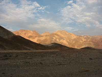
The Death Valley is one of the few places on the planet where the earth boldly puts on a naked show, with no reservations about modesty. The place results from a convergence of active geology of the Great Basin and a dry desert environment in the rain shadow of the Sierra Nevada, culminating in a colorful, incredibly vivid display of tectonic proportions. This place dispels the myth that something must be green and lush to be beautiful. The endless expense of multi-hued sand dunes, radiant playas, mirror-like salt lakes, exotic badlands, chromatic rock bands, snow capped mountains, and deeply-featured bajadas are set against a cloudless blue sky as deep as the air is devoid of moisture.

Telescope Peak and the Panamint Range

The maze-like badlands of Golden Canyon

Hole in the Wall

Zabriskie Point

The southern Amargosa Range basking in evening light

Dramatic viewpoint along the Artist Road

The Manly Beacon rise vertically out of Golden Canyon

The Flight

A flight from the L.A. basin to Furnace Creek involves one of two routes: one that skirts around the west side of the Edwards restricted airspace complex, and one that skirts to its east. Our route is of the former kind and involves a climbing detour around the west side of Vany Nuys and Burbank airspaces, followed by a direct crossing the low western San Gabriel Mountains to Mojave, through the Trona Corridor, and finally a detour around the southern end of the 11,000+ ft high Panamint Range to Death Valley proper.

Our flight route from Santa Monica to Furnace Creek airport

The last part of our flight was the most exhilarating. Flying at a mere 6,000' MSL, crossing from Trona to the Death Valley required us to tiptoe around the 5,000+ ft high Slate Range just to the west of the Panamint, as well as the higher peaks at the southern end of the Panamint Range. Vertical walls of sparsely vegetated mountains stared at us at every turn, and we were on constant lookout for turbulence and downdrafts shall they suddenly appear. It was a true mountain flying experience. Soon afterwards, we made a sharp left turn, putting us parallel to the Panamint Range. It was an eerie feeling to have a massive mountain ridge covering most of our sight lines on our left side, yet have the salt lakes of Death Valley disappear below our right wing.

The flight took about 2 hours and 15 minutes.

Monday, September 3, 2007

Shelter Cove

Smack in the middle of the most beautifully rugged coastal section in the contiguous United States, Shelter Cove is a geographical anomaly in an otherwise inhospitable, inaccessible section of California coast. Situated on a broad marine terrace, it boasts enough flatland for an airport and sheltered ocean access where no similar facilities exist for this 100 mile section of otherwise lonesome coastline. A solid, almost vertical wall of mountains three quarters of a mile high rise straight out of the ocean on both sides of the Cove, and due to active geology and erosion, much of the coastal cliff faces are entirely devoid of vegetation. Road access is similarly difficult. The town could only be reached at the end of a long, sinuous drive on a narrow spur road nearly an hour from US101. A campground, general store, and a number of motels and restaurants dot the far end of the runway. The climate and vegetation are that of a temperate rain forest, with dense forest canopy and thick undergrowth, resulting in an extremely lush ambiance. For a fly-in visitor, it's hard to find a more attractive coastal getaway than this, especially if the weather is clear. The long distance Lost Coast Trail starts near town, giving access to inland hiking trails. The Mecca of California wilderness surfing, a primo surf break with no road access, is just a half-day's hike up the coast on the Lost Coast Trail. Offshore fishing is also big here.

National Geographic Adventure article on Lost Coast surfing

Aeroventure article on flying to Shelter Cove

North Coast Journal on the Shelter Cove Saga

Shelter Cove on Google Maps

The coastal terrace of Shelter Cove

For those who long for the Golden Age of aviation, Shelter Cove shall be considered a place of solace. A place not specifically built to be a fly-in community, it is a rare specimen of a town that physically centers on a strip of airport runway. Beautiful coast-side homes line the runway, yet most residents at Shelter Cove are not aviators and do not own an airplane, and for the number of properties in town there is but a small fraction of spaces for airplane parking on the tarmac.

The first time I came to Shelter Cove, I did it like almost everybody else. Coming from the San Francisco Bay Area via the US101, it was a seemingly endless, tortuous drive along the bends of the Russian River, followed by those of the Eel River. In contrast, the air traveler arrives here at Shelter Cove in style. There is no speed limit to watch for, no hairpin turn to negotiate, and no truck to pass on the way. Just a straight line along the coast, with a most visually spectacular one at that!

Black Sand Beach and the long distance Lost Coast Trail

The Shelter Cove 9-Hole surrounds the runway

The Journey

Our largely impromptu flight route treats us to a terrific visual feast of a huge section of California coast, from the balmy beaches of Malibu and Santa Barbara, to the large crescent-shaped bays of the central coast, to the dramatic mountainous section of Big Sur, to the wide and sandy Monterey Bay, to the redwood-studded coast defined by the Santa Cruz Mountains, skirting the dense urban jungle of San Francisco, past the iconic Golden Gate, over a coastal rift valley bisected by the San Andreas fault, to the rockbound coast of Sonoma, before reaching a crescendo that defines the Lost Coast.

It was one thing to take a road trip along the coast on Highway 1, but an entirely different experience to fly over it. There was just so much that could not be seen from the road that was a staple from an aerial perspective. As if the visual thrills weren't enough, we had to remain ever vigilant for the variable coastal wind conditions and be on constant lookout for the next postage-stamped section of flatland shall a power-off landing be necessary.

Our flight route from Hawthorne to Shelter Cove and back

Our flight to Shelter Cove took a little more than 6 hours, including a refueling break at Watsonville. Our return flight took about 5 hours and 45 minutes, including a refueling break at Tracy.

Saturday, August 18, 2007

Corona

Today I went shopping at Aircraft Spruce. At Catalina, the ranger told me to bring a real mountain bike next time, so after some research, I decided to buy the Montague Paratrooper folding mountain bike. It has rugged looks and functionality, with reasonable weight and price. For a full size folding bike that fits in the airplane, this seems to fit the bill.

Saturday, August 4, 2007

Catalina Mountain Biking

Going to a new destination by plane is always exciting, and when the destination is as spectacular as Santa Catalina Island's Airport in the Sky, it is even more so. The Catalina Airport (AVX) is situated on a 1,500+ ft high plateau on the middle of the island, with the Pacific Ocean less than a mile away.

The Island itself is 26 miles from the mainland at the closest point, which is a heck of a distance to traverse by kayak, and quite a few hours away even by sailboat. Strangely enough, I have seriously considered using either of these two means to get to the island, as I have ready access to both. But for practical reasons I chose to take the ferry instead, with my favorite folding kayak as baggage on my first two visits. Having traversed the entire northern coastline from Two Harbors to Avalon and then some on a soft-hull kayak, being subjected to the forces of nature more than any motorized boater, beachcomber, and hiker would care to admit, I am quite familiar with and attuned to the island's coastal environment. Yet little did I know, far above the water line lies a totally different world that is still Catalina Island.

Just as a sea-kayak enables one to experience the coastal environment in a way that a larger vessel could not replicate, a mountain bike enables one to appreciate the wonders of the Island from a land perspective more than any larger vehicles. Much more efficient yet conducive to hiking, and unencumbered by limited bus schedules, it is a fantastic way to experience inland Catalina.

With its central high interior location, the airport serves as a perfect access point to the network of ridable dirt roads on the island. All rides start from the airport as a downhill ride, giving the rider a thrilling warm up to the rigors of biking the Island. With an early start, it is possible to ride to ANY part of the island accessible by road, and get back to the airport in time before sundown. There is also a number of readily bike-accessible campgrounds on various parts of the island that could extend one's exploration time.

There are a couple of caveats to Catalina fly-in mountain biking:

  1. There is no bike rental at the airport location; it's strictly "BYOB" or you will need to catch a shuttle bus to Avalon or Two Harbors and rent one there.
  2. Many folding bikes are not mountain bikes, and they are not allowed under the Conservancy's bike permit rules.
  3. There is an airport curfew, with varying hours depending on season, usually starting around sunset. There is a $20 landing fee. No aviation fuel is available.
  4. Under prevailing conditions, the upwind side of the airport plateau may be subjected to coastal fog due to orographic uplift, while the downwind side may be subjected to downdraft just beyond the runway's drop off.
  5. The shuttle bus that runs between the airport and other points on the Island requires advanced reservation. One therefore cannot count on a "last minute" trip back to the airport from Avalon, especially if bikes are involved.

Friday, July 20, 2007

Evening party in Santa Barbara

As private pilots, we always welcome the opportunity to make flying more than just a hobby. Today, our opportunity came in the form of a "business" trip to Santa Barbara. A friend of ours decided to throw an engagement party on a Friday evening, and were it not for the fact that we have an airplane at our disposal, we would have to take most of the afternoon off work just to make it, considering the usually horrendous L.A. traffic from El Segundo to Thousand Oaks.

We made it a point to work until almost 5pm just to see if we could make it to the party by 7:30. After a quick preflight, we took to the skies above the gridlocked freeways. We had to spend an extra 5 minutes to climb an extra 2,000 ft because we were told at the last minute that the Mini Route was unavailable due to fog. Once cleared of LAX, we made good speed direct to Santa Barbara. The GPS cruise ground speed was shown to be a steady 115 mph all the way, and we made it to the airport with slightly over an hour of air time. The party took place in a UCSB graduate student housing complex near the campus so the airport couldn't be situated in a more convenient location.

Our flight route from Hawthorne to Santa Barbara

The thing about being a VFR-only pilot is that we run on the weather's schedule, not ours. The same could be said about IFR flying too, but the latter is more affected by icing than the marine layer, which is the prevalent kind of weather here in SoCal. We made it to the party in good time, but we knew that it didn't necessarily mean we would make it back that same night, particularly when coastal fog is involved.

The party took place outdoors and we kept an eagle eye towards the clear evening sky. Luckily, the fog did not arrive early that night and we made it to Signature Flight Support before their 10pm closing. The nighttime departure via Runway 15R was a little exhilarating as we took off straight into total darkness, with no horizon reference whatsoever in our periphery. On approach over LAX the ATC gave us clearance over LAX Class B direct to Shoreline Route, which proved to be a challenging exercise because we weren't expecting to see Santa Monica covered in fog, and didn't realize the situation until we were almost directly over it. Once we cleared south of LAX we were presented with a cloud navigation puzzle before we were allowed to land back at Hawthorne amidst patchy fog. It was a great interesting flight and we all got home before midnight.

Sunday, July 8, 2007

First Passenger Flight

John and Emmy volunteered themselves to be my first non-pilot passengers in 7 years! After spending a good deal of time explaining the various parts of the airplane and taking pictures, we took off from Hawthorne in "standard" summer conditions, with moderate smog and a 10-15 mph sea breeze plus light thermal turbulence as we headed inland. I had an ice hockey league game to make later that afternoon, so instead of doing a standard "under and over LASFR" tour around the LAX Class B Surface-10,000'MSL airspace, we went over to Downtown, South Pasadena, and Alhambra instead.

View of L.A. Downtown in smog:

Sunday, July 1, 2007

Biennial Flight Review

Today I had my BFR done out of Long Beach. Getting there proved quite a challenge as LGB is a complicated maze of intersecting runways and taxiways. It was confusing even with a printed airport diagram in the cockpit. We had to say stuff like, "taxi to Long Beach Flying Club via Kilo, Bravo, and Foxtrot, will hold short of Runway Three Zero" and "request taxi to Two Five Left at Delta via Foxtrot with Charlie." It was pure alphabet soup.

The flight portion proved quite useful as well as scenic, as I got to fly the LA Special Flight Rules corridor above LAX for the first time, yielding some fantastic views of numerous sailboats dotting the ocean just off of Marina del Rey, did some air work over the ultra-blue Pacific just southwest of Long Beach Harbor, low overflight over Los Alamito's airspace and Knott's Berry Farm, before a full stop landing at Fullerton.

Interestingly, Fullerton provided some challenging gusts and crosswinds, giving me some additional insights on how our plane's nose gear steering works. It turns out, the landing gear steering spring is not necessarily tuned to give the same yawing moment as the rudder for the same rudder pedal travel. As a result, in a crosswind landing, there could be a sudden increase in yawing moment when the nose gear touches down, and a similar decrease when the nose lifts off the ground. The result could be quite alarming if the nose gear chatters between these two modes. I have developed a technique to minimize this chattering for both takeoff and landing.

Saturday, June 30, 2007

First Flight by New Owners

Today we officially became airplane owners! After a thorough inspection, a trip to the bank, and some paper work, we were ready to take it to the skies.

The Los Angeles metropolitan airspace is extremely complicated. And as new owners we had to navigate this maze of overlapping airspace in thick afternoon smog, towards the sun, without a GPS, in an unfamiliar airplane. Luckily we didn't have to do it alone, plus SoCal Approach Control gave us a little assistance. We brought her home in less than 45 minutes of air time.

At the Redlands fuel pit, getting ready for first flight by new owners

Our route from Redlands to our home base in Hawthorne